Dapeng Town Industrial Park, Tongshan District, Xuzhou City, Jiangsu Province, China
The steel roof of the base hangar of the international airport was slowly lifted into position, and the base hangar was officially topped out. At the same time, it also means that all the supporting hangar projects of the international airport have completed structural construction. The project is a large century project led by the A-party to apply BIM technology in the whole process of design and construction.
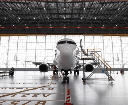
The project has a total construction area of 85,400 square meters, including hangars and annexes, business buildings, aviation material storage, the North Energy Power Center and other 15 monolithic buildings. Among them, the North Hangar has a total construction area of 28,000 square meters, which is the largest single project in the base. The hangar consists of a maintenance hangar hall and a four-story annex building, with two wide body aircraft slots or three narrow body aircraft slots, which can accommodate up to two Boeing 747s or three Boeing 777s at the same time, and can meet the flexible parking of multiple types of aircraft with different maintenance needs.

The hangar hall is the focus of the overall construction upgrade, the hall plane is 147 meters long, 99.7 meters wide, the total weight of the space frame is about 1600 tons, for the technical difficulty and span of the project, the project team adopted the method of “ground assembly + overall lift” to complete the steel roof space frame upgrade.
Due to the complex structure of the large-span steel space frame, complicated installation process and high positioning accuracy of the project, it is the key of this project to enhance multi-party collaboration in order to scientifically enhance the project progress, improve the project quality and reduce the project safety risk. The project has fully implemented the BIM application of the whole life cycle of the project led by the Party A and multiple participants, realizing the information transfer and information sharing based on BIM standard in all stages of investment planning, survey and design, construction and operation and maintenance of the project, meeting the demand for quality control and project progress and investment control in different stages of the construction.
In the construction preparation stage of the project, the project department requested the steel institution unit to use BIM technology to carry out special deepening design and performance analysis of the steel space frame to ensure that the steel frame is in line with the use requirements and can strictly control the stress point parameters in the construction process to meet the lifting requirements. After undertaking the work task, we used Revit, Tekla and other related technical tools to carry out 3D modeling, deepening collaboration, stress calculation and other work on the hangar steel space frame.
Based on the standardized products, BIM Management Center actively innovates according to the characteristics of civil aviation construction field and continues to promote the research and development of BIM engineering collaboration platform in civil aviation construction field.
The project company integrates the information data of steel structure deepening design through the collaborative platform and uses cloud technology to achieve off-site approval and synchronous work of design-construction-supervision and other units. In the process of structural deepening, BIM cloud technology was used to discover 3 important design coordination issues and independently complete the 3D dimensional verification of the positioning of the horse path installation through BIM technology, which effectively promoted the progress of the project.

Three-dimensional laser scanning technology, also known as high-definition measurement, it is the use of the principle of laser ranging, by recording the three-dimensional coordinate information, reflectivity, texture and other information of the surface points of the object under test, the three-dimensional data of the entity under test and the scene is completely collected into the computer, and then quickly reconstruct the three-dimensional model of the target under test and lines, surfaces, bodies, and other graphic data. The maintenance hangar steel space frame construction program, according to the site working conditions, scanning the main object, scanning accuracy, scanning time, schedule, the final choice of two 3D laser scanner (Topcon GLS2000 (medium and long-range), Ten Pao TX5 (proximity)), a measurement robot (Ten Pao RTS873), a laptop workstation (Lenovo), related supporting software.
Measuring robot is a fully automatic and high precision total station with world leading level. It can be operated directly by handbook (small notebook) without eyepiece, and can import CAD plane coordinate drawing, 3D coordinate drawing, and Revit model (BIM model) into the handbook, and then measure by the instrument.
Combined with the actual situation of the hangar space frame elevation and the characteristics of three-dimensional scanning, the control points evenly cover the entire construction survey area, and 8 coordinate control points of the scanning area are laid according to the first level measurement datum provided by the survey and mapping institute to the survey area to realize the coordinate alignment of the three-dimensional control network and the construction coordinate system on site. Through the total station wire measurement and data leveling processing, to obtain high-precision coordinate results.
According to the space frame lifting specification requirements and space frame construction program requirements, the steel structure space frame lifting high precision requirements, we take into account the assembly and construction of comprehensive precision, need to do high-precision measurement control network, control point layout as shown above, control network accuracy as follows: to ensure the scanning accuracy needs, the accuracy of the control network will reach 1/57000, the use of high-precision measurement robot Leica TS30 for control measurement, the distance measuring accuracy can reach 0.6mm+1ppm, and the angle measuring accuracy can reach 0.5″.
Hangar space frame lifting 3D laser scanning measurement is mainly carried out in 5 stages, with a total of 5 scans; i.e. space frame and steel column scanning after the hangar space frame is assembled on the tire frame, space frame scanning around the space frame after pre-lifting, static scanning at the top stop stage, arch detection scanning after the installation is completed, and deformation scanning after all loading is completed.
BIM center and construction units can simulate the real and dynamic construction schedule through BIM5D software. During the simulation, many problems in the plan are exposed, such as safety measures, sub-project plan conflicts, site layout and other unreasonable problems, all of which will affect the actual project schedule, and choosing the most practical plan can shorten the project construction cycle. Using the comparison function between planned and actual progress of BIM5D, the weakness of construction stage progress management in the original management system can be reinforced. Based on the monthly progress comparison of BIM5D platform and regular aerial photography of drones, we analyze the problems of site progress, detect the execution of progress, and provide advance warning for the subsequent progress.
As one of the airport construction units, it actively carries out reform and innovation of the existing engineering management mode, improves risk control ability, scientifically enhances engineering progress and effectively coordinates engineering resources. By practicing the combination of BIM technology and other engineering management means, the base aircraft maintenance project has realized the combination of BIM technology with weekly engineering reports, aerial photography by drones and 3D scanning, optimized the quality of unified data model, improved the effectiveness of integrating and utilizing data information in all stages of the project, enhanced the visualization of management, and effectively improved the refinement of the whole process of construction plan optimization, collaborative construction, quality management, safety control, etc. It has set a model for the application of BIM technology in large airport projects and accumulated data assets for the construction of other similar projects.